Zone Charity (Healthier Society) Economic Development
ஆரோக்கியமான சமுதாயத்தை நோக்கி ZoneCeylon.lk உம் அதன் உட்கட்டமைப்பும்.
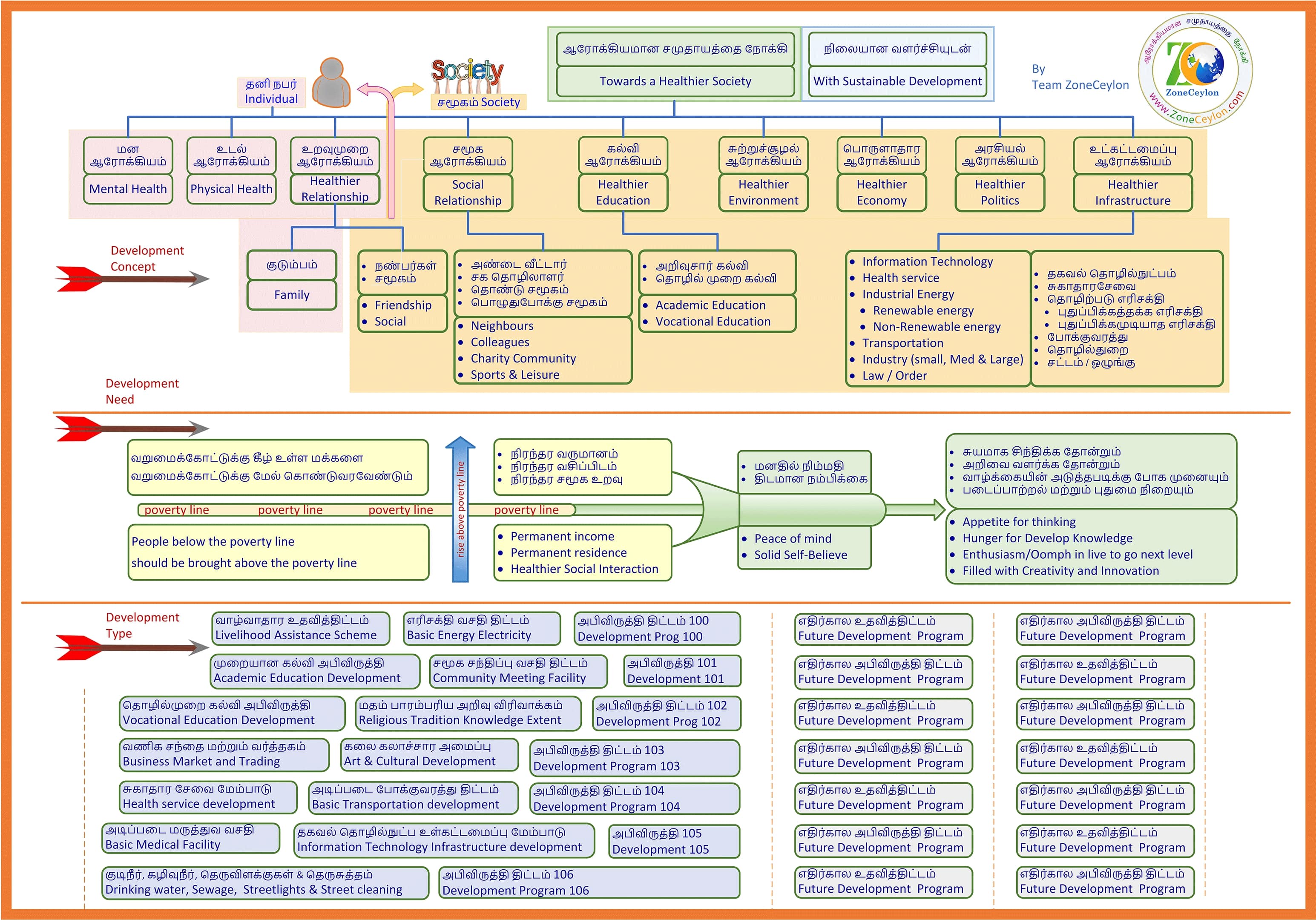
இலங்கைத் தமிழரின், கலை கலாச்சாரம் பண்பாடு பாரம்பரியமும், அறம் ஒழுக்கநெறி முறையான-வாழ்வுமுறை என்பன சிதைக்கப்பட்ட நிலையில் பலர் வறுமைக்கோட்டிற்கு கீழும் தள்ளப்பட்டுள்ளனர். இவற்றை சீர்திருத்தி வழிமுறைப்படுத்தி மீண்டும் ஒரு உயிர்ப்பான ஆரோக்கியமான தமிழ் சமுதாயத்தை கட்டியெழுப்பும் தீர்மானத்துடன் நாம் உங்களை அணுகுகிறோம்.
“ஆரோக்கியமான சமுதாயத்தை நோக்கி” என்ற தோரணையில் நாம் ஆரம்பிக்கும் இந்த செயல்முறைத் திட்டத் தொடர்களை நாம் இங்கு சுருக்கமாக சொல்கிறோம்.
வயிற்று பசியுடன் வறுமைக்கோட்டிற்கு கீழுள்ள மனிதனால் சரியான சிந்தனையுடனும் நேர்த்தியான செயற்பாட்டுடனும் இயங்குவது மிக சிரமம். அதனால் முதலில் வறுமைக்கோட்டிற்கு கீழ் உள்ள மக்களை வறுமைக்கோட்டிற்கு மேல் கொண்டுவரும் திட்டங்களை அமுல் படுத்தவுள்ளோம்.
இதற்கான நிறுவன அமைப்புடன், உள்கட்டமைப்பு ஒன்றையும் அமைத்துள்ளோம்.
இது எப்படி வேலை செய்யும் என்பதை பார்த்தால். நாம் சேகரிக்கப்போகும் முழுமையான தரவுகளை ஒழுங்கமைத்து அவற்றை திறமையாகக் கையாளும் வகையில் எமது தரவுத்தளம் இடமளிக்கும்.
பின்வரும் தரவுகள், சமூக-நிலைப்பாடு, வறுமை, கல்வி, சுகாதாரம், சுற்றுச்சூழல், குடிநீர், கழிவுநீர், பொருளாதாரம், சட்டம்/ஒழுங்கு போன்ற தரவுகளும். உட்கட்டமைப்புகளான எரிசக்தி, போக்குவரத்து, சுகாதார-சேவை, மருத்துவ-வசதி, தொழில்நுட்பம், கலை-கலாச்சாரம், வணிகம்-வர்த்தகம், மதம்-பாரம்பரியம் போன்றவைகள் சேர்க்கப்பட்டு இணைக்கப்படும்.
இத் தரவுகளை அலசி ஆராய்ந்து நாம் தேவைகளுக்கேற்ப நேர்த்தியான அபிவிருத்தி திட்டங்களை முன்வைப்போம். கூட்டத்தில் நிதி திரட்டும் பிரச்சாரமாக அதனை அறிமுகப்படுத்தி. திரட்டப்படும் நிதியை நம்பகமான மற்றும் வெளிப்படையான முறையில் தெரிவுபடுத்தி, அபிவிருத்தி திட்டங்களை பங்களிப்பவர்களின் திருப்திக்கும் மனநிறைவிற்கும் ஏற்றவாறு செவ்வனே செய்து முடிப்போம்.
ஓரளவுக்கு வறுமைக்கோட்டுக்கு கீழுள்ள மக்கள் மேலேவரத் தொடங்குகையில், நாம் அடுத்தகட்ட பொருளாதார வளர்ச்சிக்குரிய வேலைத்திட்டங்களை முன்வைக்க தொடங்குவோம். நாம் முதலில் குடிசைக் கைத்தொழில், அதை தொடர்ந்து, மைக்ரோ இண்டஸ்ட்ரி எனும் பாதையில் போக முனைவோம். அவற்றின் விரிவாக்கம் பின்வருமாறு.
குடிசைத் தொழில் என்பது ஒரு சிறிய உற்பத்தி வணிகமாகும், இது ஒரு தனிநபர் அல்லது குடும்பத்தால் சொந்தமானது மற்றும் இயக்கப்படுகிறது, பொதுவாக ஒரு நோக்கத்திற்காக கட்டப்பட்ட வசதிக்கு பதிலாக ஒரு வீட்டில் இயங்குகிறது.
மைக்ரோ இண்டஸ்ட்ரி, மைக்ரோ பிசினஸ் என்றும் அழைக்கப்படுகிறது, இது சிலருக்கு வேலை செய்யும் சிறு வணிகத்தைக் குறிக்கிறது. ஒரு மைக்ரோ என்டர்பிரைஸ் பொதுவாக 10க்கும் குறைவான நபர்களுடன் இயங்குகிறது மற்றும் ஒரு வங்கி அல்லது பிற நிறுவனத்திடமிருந்து மேம்பட்ட சிறிய அளவு மூலதனத்துடன் தொடங்கப்படுகிறது. பெரும்பாலான சிறுதொழில் நிறுவனங்கள் தங்கள் உள்ளூர் பகுதிகளுக்கு பொருட்கள் அல்லது சேவைகளை வழங்குவதில் நிபுணத்துவம் பெற்றவை.
இப்படியாக நாம் அடுத்த கட்டத்தை அணுகும் போது அதட்கேட்ப சிந்தித்து செயற்படுத்திக் கொள்ளலாம். எமது முக்கியமான நோக்கம் தமிழ் சமுதாயத்தை பொருளாதார வளர்ச்சியில் மேற்படுத்தி, ஒரு தன்னிறைவான சமுதாயமாக மாற்றியமைப்பதே. எம்முடன் சேர்ந்து ஆரோக்கியமான சமுதாயத்தை நோக்கி பயணிக்குமாறு அன்புடன் அழைக்கிறோம்.
Explore Now
Zone Obituary Services
மரண அறிவித்தல், நம்முடன் இதுவரை காலமும் பயணித்தவர்கள், இனி எம்முடன் பயணிக்கமாட்டார்கள் என்று நினைக்கையில், எமது வாழ்க்கையில் ஒரு வெற்றிடத்தை உருவாக்குகிறது. இதைமாற்றி அவர்கள் நினைவு எம்முடனும் அவர்கள் வாழ்ந்த மற்றும் விரும்பிய சமூகத்துடனும் என்றென்றும் இணைத்திருப்பதற்காக, நாம் உருவாக்கியதே எமது ZoneRIP இணையத்தளம் ஆகும்.
இந்த தளத்தில் நீங்கள் தினமும் சாமி அறையில் கும்பிடுவதற்கு விளக்கு ஏற்றி பூஜை செய்வதுபோல், விளக்கு ஏற்றலாம், பூக்கள் தூவலாம், ஊதுபத்தி எரிக்கலாம், தேவார பாடல்கள் பாடலாம்.
நீங்கள் விரும்பிய அளவு நினைவு தொகுப்புகள் போடவும், அவர்களின் ஞாபகமாக இருக்கும் படங்களோ விடீயோக்களோ இணைத்துக்கொள்ளலாம்.
ஒரு அறிவித்தலை போடுவதற்கு கொடுக்கப்படும் செலவுக்கட்டணம் நீங்கள் விரும்பிய தொண்டு பணிக்கு (Charity Project) நேரேயே போகும், Charity Project இற்கு குறைந்தபட்சம் £200 களும், மேலாண்மை தகவல் அமைப்புக்காக £100 களும் மொத்தமாக £300 களும் செலுத்தவேண்டி வரும். இது வாழ்நாள் முழுவதுக்குமான தொகை (payment for lifetime) .
நீங்கள் விரும்பியவாறு ஒவ்வொரு வருடமும் திவசம் மற்றும் திதி நாட்களுக்கு தேவையானபடி பக்கங்களை போட்டுக்கொள்ளலாம். இந்த சேவையை நாம் உங்களுக்குரிய தனிப்பட்ட இடமாக (Personal Space) ஆக வழங்கப்படும்.
நீங்கள் வழங்கிய £200 தொண்டு பணிக்கு (Charity Project) உரிய பணத்தின், புராஜெக்ட் இற்குரிய செலவு விபரங்களும், அது நடந்தேறும் விபரங்களும், நன்றி தெரிவித்தாலும், உங்களுக்கு தொடர்ந்து வரும்.
இதன் மூலமாக உங்களுக்கு ஒரு ஆத்ம திருப்தியும், அமைதியும் நிலைக்கும் என்று எதிர்பார்க்கிறோம். நம்முடன் இருந்தவர் இனி இல்லையென்று போட்ட அறிவித்தலுக்கு கொடுத்த பணம் ஒரு நல்ல சமூக செயலுக்காக பாவிக்கப்பட்டு, பயன் பெறுபவர்களின் வாழ்த்துக்களுடன், எம்முடன் வாழ்ந்தவர்கள் தொடர்ந்துமே எம்முடனும் எமது சமூகத்துடனும் வாழ்கிறார்கள்.
சமூக சேவைக்கு உங்கள் அன்பளிப்புக்கு மிகுந்த நன்றியை தெரிவித்துக் கொள்கிறோம்.
Explore Now